In this post you’ll find everything you need to know about hiking the Mount Toubkal trek, including routes, costs, preparation, what to pack and what to expect.
Some of the links in this post are affiliate links. All this means is that if you make a purchase through one of the links I have provided, I will earn a small commission as a result but the cost to you will remain exactly the same.
My friends and colleagues called me crazy when I told them I’d be spending almost the entirety of my four-day ‘holiday’ to Morocco climbing a mountain and sleeping in rudimentary mountain refuges at night, sharing a room with around 20 other hikers who may or may not have showered in the last few days.
Ok, I admit that I’m not a huge fan of the latter (pack your ear plugs and sleep mask!) but it’s all part and parcel of completing the three-day Mount Toubkal trek, and reaching the 4167 metre summit of North Africa’s tallest mountain.
The friends who I made the climb with had the slightly more sensible idea of spending a few days in Marrakech beforehand, to enjoy some relaxation time and an opportunity to acclimatise to the heat. Whereas I decided to finish work on the Friday, travel to Marrakech on the Saturday (I left my hometown at 10am and arrived in Marrakech’s medina 12 hours later) and then start hiking on the Sunday.
I won’t mention the fact that I arrived home at 4:30 a.m on the Thursday and was at work four hours later. Ok, my friends and colleagues may have been right after all 😉
Where is Mount Toubkal?
Mount Toubkal is located 63 kilometres south of Marrakech. The start and end point of the Mount Toubkal trek is the village of Imlil, 1800 metres above sea level. Imlil is a 90-minute drive from Marrakech.
When is the best time of year to make the climb?
This depends on exactly how much you want to challenge yourself!
Climbing Mount Toubkal in the Summer is difficult due to the heat (there’s not much shade on the trail) and in the Winter it’s bitterly cold and you’ll need additional equipment like crampons and ice picks. So the Winter climb is a lot more technical and also more dangerous due to the snow and ice.
For the optimum conditions on the trail, the best time of year to do the Mount Toubkal trek is Spring (April or May) or Autumn (September or October). We chose the former because we’d heard that there should still be traces of snow on the peaks and also some colourful Springtime flowers in bloom, both of which we thought would be good from a photographic point of view.
How fit to I need to be?
It’s not a technically difficult climb, but there are long days of hiking and lots of relentless uphill sections. I’d say that as long as you have a reasonable level of physical fitness and a positive mental attitude, then you’ll be fine. I don’t consider myself to be very fit, but I do lead a moderately active lifestyle. I walk to work and back every day, go running twice a week and usually hit the gym once or twice at the weekend.
One of the main issues with the Mount Toubkal trek is the altitude and the speed at which you ascend and descend. We climbed 450 metres on the first day, a whopping 1400 metres on the second day and then a further 1000 metres on the third and final day. And then we made the 2850 descent all in one go, with a short break for lunch.
Hiking when you’re suffering from altitude sickness is hard. Sometimes the symptoms can be so bad that you have no choice but to retreat to a lower altitude. Sometimes the symptoms come on so quickly and severely that you cannot even manage that. In that instance four-legged help would likely be utilised in order to transport you back down the mountain as fast as possible.
Although no-one is immune from altitude sickness, you can take the following precautions:
- Climb slowly. There’s no point rushing to the top when doing so could mean you won’t make it there at all.
- Eat carbs. When you’re at higher altitude you need more calories. So this is probably one of the few occasions you can gorge guilt-free on bread, pasta and potatoes. One of the symptoms of altitude sickness is a loss of appetite, so it’s important to eat even when you’re not feeling particularly hungry.
- Drink water. I’m so bad at remembering to drink water on hikes, but I made myself stop regularly to take a drink on this one and it absolutely paid off – apart from a bit of a headache on the way down, I didn’t suffer an ill effects at all.
- Avoid alcohol. This wasn’t hard for us in a Muslim country during Ramadan, but in most other situations, the temptation to have a cold beer at the end of a hard day’s hiking will probably be difficult to resist.
If you do get a headache, taking one or two ibuprofen tablets can help.
How long do I need?
It is possible to complete the ascent and descent in just two days (first day seven hours, second day around 10), but this route does involve returning to Imlil along the same trail you hiked in the opposite direction the day before.
Due to the high altitude, we didn’t want to rush the climb. We also didn’t particularly want to retrace our steps (although you do have to follow the same route up and down for the final part of the climb from the Toubkal refuge to the summit), so we chose a circular route, which is completed over three days.
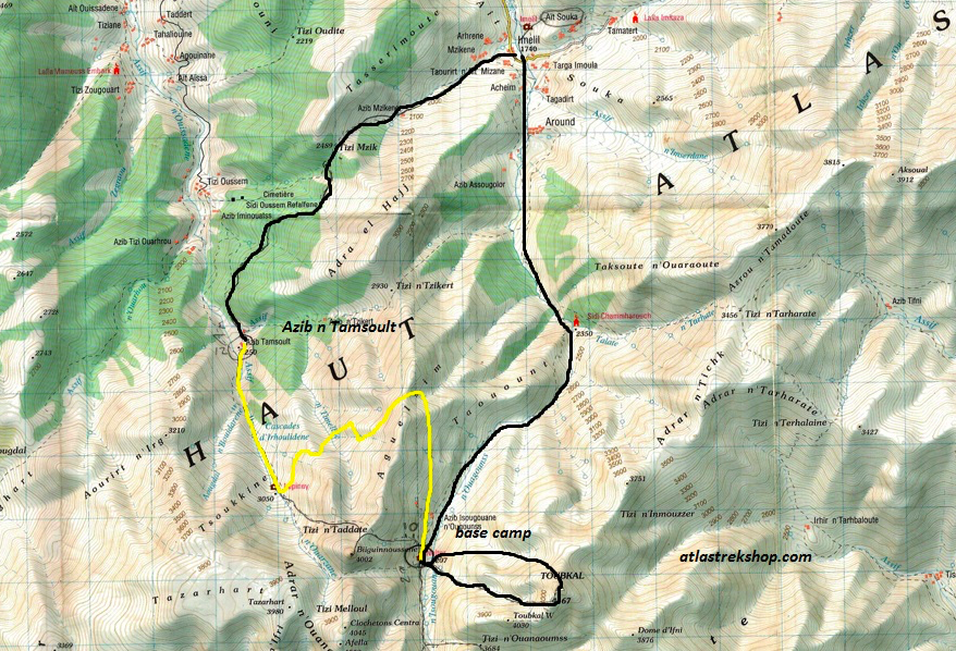
Photo credit: Aztat Treks (atlastrekshop.com)
It’s also possible to book longer treks, which include stays in traditional Berber villages. Having previously embarked on a similar adventure through the Atlas Mountains (but without the Mount Toubkal climb), I can thoroughly recommend this option if you have more time.
Can I make the hike independently?
Not anymore. Following recent events (a couple of Scandinavian hikers were murdered in 2018 and there has been more than one fatal slip on the trail), qualified guides are now required even for the normal Mount Toubkal trek routes.
What should I pack?
This all depends on the time of year, but for an April/May climb, I’d recommend the following. The temperatures on the trail should range between 7 and 26 degrees, meaning it gets pretty chilly in the morning and at night, but daytime temperatures are pleasantly warm.
- Good, sturdy, worn-in hiking boots. I wore my Keen hiking boots.
- A comfortable, well-fitting day-pack. Around a 20-litre capacity should be sufficient. I try not to pack too much because, well, I’ve got to carry it all. And my DSLR already weighs a ton. I love my Osprey Tempest.
- Leggings. These take up less room than walking trousers, offer better freedom of movement, and are a lot more comfortable in my opinion. My favourite brands for leggings are Sweaty Betty and North Face.
- Good hiking socks.
- Quick-drying tops. I was advised that I should keep my shoulders covered (it being a Muslim country ‘n’ all), but I hate hiking in the heat when my underarms can’t breathe, so I did pack a couple of sleeveless tops as well as tees. I took Salomon, Sweaty Betty and Rab tops.
- A hat. There’s not a lot of shade on the trail, so a hat or cap will help to protect your head from the hot sun overhead.
- Sunglasses, obvs. Just make sure you get some that offer sufficient protection, preferably with polarising lenses.
- A head torch. Because you will be making the first section of final part of the climb to the summit in the dark. It’s also helpful to find your way to the bathroom in the middle of the night.
- Waterproof jacket. Weather is always a lot more unpredictable up in the mountains. We were lucky and I didn’t need mine, but there are no guarantees you will be. My Rab Downpour Jacket has never let me down, even when it was tested to its limit in Kerala.
- Waterproof backpack cover. Because there’s no point in keeping yourself dry if you’re going to have to put soaking wet clothes on at the end of the day. Electrical equipment (cameras, phones, chargers) and water aren’t friends either.
- Mosquito repellent. It appears that mosquitoes are not deterred by the altitude. I prefer to use natural mosquito repellents and find that they are just as effective.
- Long sleeve tops and a fleece to wear at night and first thing in the morning before the sun has fully risen. My current favourite fleece is this one by Rab. I love the seaglass colour and the fact that it has zipped pockets.
- Flip flops or alternative footwear to change into at camp. Believe me, after seven hours (or more!) of hiking, your feet will not want to stay in those hiking boots a moment longer!
- A quick-drying towel. I use this microfibre travel towel by Lifeventure.
- A light down jacket. I take this Rab Microlight Alpine Jacket with me on every trip and I love that it comes with its very own stuff sack (like a sleeping bag, so you can attach it to your backpack when not wearing).
- Trekking poles. Although you can complete most of the trek without them and I am usually much more comfortable hiking without poles, I must admit that they were helpful for the latter part of the final summit. You can hire these though, so there’s no real reason to pack them. The same applies to a sleeping bag.
- Ear plugs and a sleep mask. Because it’s the only way you’ll get a decent night’s sleep when staying in those mountain refuge dorms.
What can I expect from the trek?
In short, you can expect some incredible mountain scenery, gruelling climbs and welcoming Berber hospitality. But, as I’m sure you’ll want the answer in a little more detail, here’s what you can expect from each of the three days on the Mount Toubkal trek.
Day 1 | Mount Toubkal Trek | Approx. 5 hours of walking
Our guide and driver met us in Marrakech at 8:30 a.m on the first day of our trek. We’d transferred everything we needed for the Mount Toubkal trek into our daypacks and left the remainder in our main packs, which we could store for free at the trekking office in Imlil.
We had a short wait at the trekking office whilst our guide, cooks and muleteers got everything ready for our hike. However, as is tradition in Morocco, there was a plentiful amount of mint tea for us to drink while we did so.
We left Imlil somewhere around 10:30-11:00 a.m, climbing steadily as we did so. This is the part of the hike where the scenery is the most lush. Dense evergreen forests cover the valley floor, trees line the pathway and patches of bright yellow flowers create vibrant bursts of colour across the lower mountain slopes.
Another thing you’ll notice as being present on the lower slopes (but that disappears the higher you climb) is the sound of of bleating goats. Very quickly it became such a comforting, familiar sound that always managed to put a smile on my face.
Today’s hike is relatively easy in comparison to the following two days, but it will also probably be one of the warmest (heat doesn’t rise in the mountains; you lose around 10 degrees with every 1000 metres you climb) so you will still rejoice when you arrive at one of the mountain cafes serving huge glasses of freshly squeezed orange juice for just 15 dirham (£1.22).
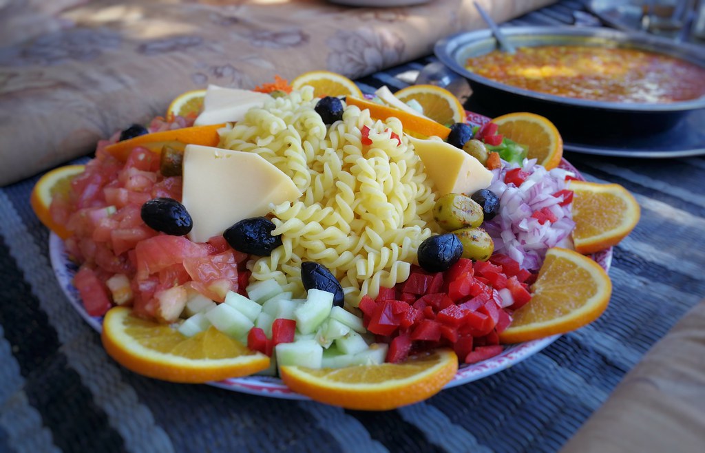
Incidentally this was also the location of our lunch stop, 2489 metres above sea level and after around two hours of steady uphill walking. Our guide and porters assembled a couple of mattresses for us to sit on under the shade of the trees, and within minutes we were filling our bellies with a veritable feast of tomato, pepper and bean casserole, and an amazing pasta and cheese salad spread, accompanied by Moroccan bread and washed down with copious amounts of sweet mint tea.
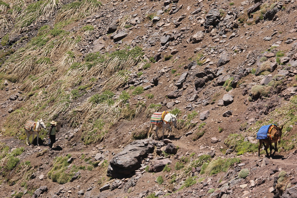
Like my Inca Trail trek in Peru, I was amazed by the kind of food the cooks turned out on our Mount Toubkal trek, considering that all the food and everything they needed to prepare and cook it with had to be carried on the back of mules up the mountain.
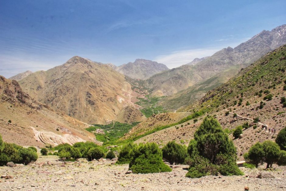
And, in front of us while we ate, these are the kind of views we were rewarded with.
After lunch we started our descent to the village of Tamssoult, 2250 metres above sea level.
The narrow track clings to the edge of the mountain, sometimes a little too precariously for comfort considering the number of loose rocks around. The spectacular views are both a help and a hindrance, providing a welcome distraction from the sight of your own feet but also the temptation to take your eyes of the track for a little while longer than it’s necessarily safe to do so.
We made plenty of water and photo stops though, before beginning our approach down to the Azib Tamsoult mountain refuge – our home for the first night of our three-day Mount Toubkal trek.
We had a sunny terrace to sit out on and enjoy countless cups of sweet, warming mint tea, surrounded by fertile farmland, grazing mules and goats bleating as they made their way down the mountainside on the opposite side of the valley 🐐🐑
We also had hot (yes, properly hot – and powerful!) showers. Considering that I’d not anticipated having anything more than a bit of cold water to wash in, this was absolute bliss!
I’d advise you to take full advantage of the washing facilities here because those at the next refuge really have nothing on those at Azib Tamsoult!
Day 2 | Mount Toubkal Trek | Approx. 7 hours walking
Breakfast was served at 4:30 a.m on day two, for a 5 a.m departure. You may not feel like eating at this time of the morning, but trust me, you’ll need the fuel; the second day of this Mount Toubkal trek is a constant stream of relentless uphill stretches.
Be prepared for plenty of river crossings today as well. I haven’t got the best balance in the world so these aren’t my favourite, although I must admit that I was more concerned about the damage it would do to my DSLR if I fell in, rather than the actual concept of falling in. I was constantly taking my camera in and out of my backpack for the initial section of today’s climb.
However, it was lovely to witness the sun slowly rising up above the mountains.
To begin with, just the very tips of the mountain peaks were bathed in soft golden light, and then gradually more and more of the landscape would move from shadow into sunlight.
The majority of our climb out of the Azzadene Valley was along winding mule tracks that zig-zagged their way, seemingly endlessly, towards the Aguelzim Mountain Pass. I won’t deny it, in parts it was tough, and did require a lot of stubborn determination to make it through.
The best advice I can give you is to find your pace and to continue at that steady pace, stopping only briefly to catch your breath or to take a drink.
The photos unfortunately do not accurately reflect just how steep a climb this was and how thin the air was getting at over 3500 metres above sea level.
At the top, the views really were something else. We could literally see for miles, and it didn’t feel as though we could climb any further. And indeed we wouldn’t be on day two; we’d already made our 1400 metre ascent from 2250 metres to 3650 metres before we sat down to eat our lunch, and our legs knew about it!
From this point onwards, we once again followed a narrow ledge that clung to the edge of the mountain, craggy peaks rising up on either side of the valley.
By the time we stopped for lunch, it had been a very long time since breakfast and although we’d snacked on dried fruits and nuts along the way, we were all absolutely starving! That said, we still couldn’t finish the delicious feast our cooks had prepared for us.
Seeing as though our guide and our cooks and muleteers were all observing Ramadan (I honestly don’t know how they do these treks without eating or drinking a single thing from 4 a.m until 7:30 p.m every single day for a month!), the mules ended up eating everything we couldn’t manage. Ramadan is probably their favourite time of year 🙂
After lunch, we were on the home stretch to Les Mouflons mountain refuge, where we would spend our second night of the Mount Toubkal trek.
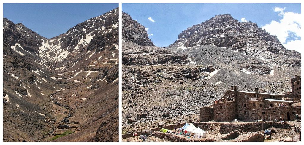
This refuge was a lot bigger and busier than Azib Tamsoult, and unless you fancy a luke-warm shower in the dark, I really wouldn’t bother with the bathrooms here. Every bed in our 16-bed dorm was taken before the evening arrived, and after realising that there was only one ladder down from the upper 4-bed bunk, I felt quite glad to have gotten there early and snagged one of the mattresses on the lower bunk.
It’s also worth pointing out that electricity is only switched on in these mountain refuges at around 6 p.m, and there’s usually only one or two sockets in each dorm, so good luck managing to get any of your electronics charged. Pack a portable battery charger. Mine has been a life saver on countless occasions.
Seeing as though we’d be setting our alarms for 3 a.m the next day, in order to leave for our Mount Toubkal summit climb at 4 a.m, we ate dinner at around 6 p.m – giving our guide and cooks enough time to clear up after our meal before breaking their fast and eating their own.
Day 3 | Mount Toubkal Trek | Approx. 10 hours walking
I think I must have been the only one in our dorm who slept almost all the way through the night. Jayne had to shake me in order to wake me the next morning, I hadn’t even heard the alarm with my ear plugs in! Seriously, get yourself some ear plugs; I never travel anywhere without mine.
We were all feeling a little apprehensive about this final part of the climb, partly because our guide had warned us that the ascent was much steeper than the day before, partly because we’d read online about how the upper section of the mountain is littered with scree slopes, and partly because we were worried about how much the altitude would affect us, having a further 1000 metres to climb, in order to reach the summit.
Our guide, Mohamed had strongly advised us that we use walking poles for this section, so we duly retrieved the ones we’d hired (that the mules had been looking after for us up until now), and set out in all our warmest layers and with our head torches illuminating our path ahead.
I actually prefer making steep climbs in the dark, because I think it helps not being able to see the route ahead. It was the same with the Trolltunga hike that I completed last year as part of a six-day budget adventure in Norway. When Jayne and I were making the final part of our descent from Trolltunga back towards the trailhead, we couldn’t believe it was the same section we’d walked up nine or ten hours beforehand. Yes, our legs were a lot more tired at the end of the hike than they were at the start, but that last downhill section was relentless, whereas at the start it hadn’t actually seemed that bad.
The initial section of our final Mount Toubkal climb consisted of scrambling over large boulders, which is rather difficult when you have a walking pole in each hand that you keep getting stuck between the rocks. I consistently had to throw my poles aside whilst I used my hands to pull myself up between the boulders and to steady myself as I walked. Half an hour in and I was getting ready to abandon them completely. Fortunately though, they were a lifesaver further up, so overall I’m glad I took Mohamed’s advice.
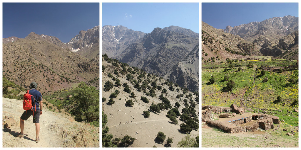
The final part of the climb to the summit of Mount Toubkal was certainly the most varied in terms of the kind of terrain you have to cross and the kind of challenges you’re presented with. For that reason, it required a lot more focus and concentration, which made it difficult to hike with my DSLR slung over my shoulder as I had done thus far. As a result, I don’t have many photos of this part of the climb. But here are a few mobile shots of a snowy section that was particularly treacherous – and freezing! Pack some gloves. I didn’t and had to borrow some from another more organised hiker.
I didn’t actually find day three of the climb as hard on the legs as day two had been. I did have to check my breathing a couple of times when I noticed myself getting short of breath, but on the whole I found it more of a slog than a battle.
And we were at the top in a period of time that felt like a lot less than the (just shy of) four hours it had taken us. My advice for an equally painless ascent is to think back to Aesop’s Fable, ‘The Tortoise and the Hare,’ where “slow and steady wins the race.” Successful high altitude climbs are all about being the tortoise: ascend slowly and keep a steady pace. You’ll likely be trekking with a group anyway, so you’ll need to stay relatively close to the guide or guides and other group members.
At the top, we couldn’t have asked for better conditions. The previous day it had reportedly been really windy and the day after rain was forecast. But on the morning we reached the top we had nothing but sunshine and blue skies.
My only complaint about about the summit was that we weren’t given long enough up there before making our descent. By the time I’d congratulated my fellow hikers, downed a ton of water, and waited patiently for my turn to pose in front of the heavily-graffitied pyramid-shaped summit marker, Mohamed was gesturing that it was time to leave. I would’ve appreciated maybe just 10-15 longer in order to snap a few more photos.
It was, after all, the only time I was going to find myself up there, 4167 metres above sea level, looking down upon the craggy peaks of the High Atlas Mountains.
The route down to the refuge seemed a lot longer than the route up had been (even though it actually took us just over half the amount of time), and I can’t quite believe that I managed to avoid falling over considering the amount of times I slid on the loose scree. Downhill is definitely not my friend!
We were all so ready for lunch at 11:30 – which was actually equivalent to eating lunch at 3:30 p.m, if we’d have woken up at a reasonable hour. After lunch we began our long (around 4 hours) walk back to Imlil. Although this route was a lot busier than the one we’d walked from Imlil, the scenery was absolutely stunning, and we could look back down the valley to the snow-capped peaks of the mountains we’d climbed earlier that day.
We kept ourselves entertained by singing (if you can call it that in my case) to each other. Mohamad sang a lovely traditional Berber song and I returned the favour by singing the theme tune to ‘Fraggle Rock’! Hey, what can I say? It’s upbeat, it’s short, and I know all the words to it 😉
Towards the end of the hike, my legs were so tired that even the soles of my feet were aching. I felt such an overwhelming sense of joy when we finally spotted Imlil in the distance.
But of course, we couldn’t rest just yet; we still had to make it back to the trekking office in order to pick up our transport back to Marrakech.
It had been an exhausting but exhilarating trek, and one I’m so glad I finally got to tick off my wish list.
Practical info
- We booked our trek through Aztat Treks, primarily due to their fantastic customer reviews, and we weren’t disappointed. We paid £190 ($241) per person, which included all accommodation, meals and transport to and from Marrakech, as well as a guide, cooks, mules and muleteers. As we didn’t want risk being part of a large group, we paid a premium for Mohamed to take solely the three of us. The cost of the trek comes down the more people there are booked on to it.
- We stayed in this lovely Airbnb in Marrakech before and after our trek.
- We booked our return flights from Manchester to Marrakech via Skyscanner – a site I use religiously for researching and booking flights. I paid £85 for mine, but Jayne and Rob got theirs slightly cheaper, due to travelling out on a different date.
If you like this article, please share it on social media using the share buttons at the top of the post. And if you’d like to save it for reading later, why not pin to one of your Pinterest boards? Alternatively you can follow along on Facebook, or Twitter, or you can look me up on Instagram or Pinterest too!











5 Comments
Nice Article Kiara!
Mount Toubkal is absolutely gorgeous, your photos are amazing. Quick question though, in terms of gear that you took, what would you say was an absolute must have for anyone else looking to do the same trek? Apart from the basics.
Hi Eddy 🙂
I did try to answer this in my article under the ‘What to Pack’ section. If I assume the basics to be hiking boots and clothing, I would definitely suggest that a head torch, warm layer and ear plugs/sleep mask are definite musts on top.
Wow, this trek looks so amazing Kiara! And your photos do it great justice 🙂 You must have been knackered by the end of it though!
Thank you 🙂 and I absolutely was! I woke up the next morning and could feel every muscle in my thighs. It hurt to bend down and walk downstairs, and even walking wasn’t completely pain-free!
Thanks for an amazing article! What a wonderful landscape. Must admit I get quite jealous when I read and see all the wonderful pictures.